Purwell 'ring of springs' walking ROUTE 3 in more detail
From the ‘centre’ of the Purwell 'ring of springs' (Grove Road TL194304)
- to (past) Dog Kennel farm (TL176283)
- to Wellhead at Charlton (TL175276)- to (past) Dog Kennel farm (TL176283)
- to St. Ibbs in St. Ippolytes (TL195260)
- to the Centre of the 'ring of springs'

The Centre of the Purwell 'ring of springs'
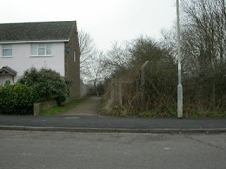
Grove Road facing South towards Hitchin
Route 3 starts at the centre of the 'ring of springs' and follows the River Hiz towards the centre of the market town of Hitchin.
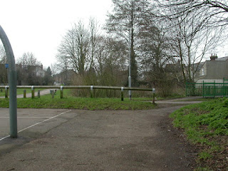
The centre of the Purwell 'ring of springs'.
The walled area in the middle of the picture marks the centre of the Purwell 'ring of springs'. It is where the River Hiz meets the River Purwell and runs through two culverts under Grove Road.This is the spot where I hope to have a plinth erected to mark the spot and to create kingfisher nesting boxes with entrances to face both rivers.
Also, I would like to have a bridge over the river to offer easy access to the spinney and to the walk that could lead to Walsworth Common without negotiating the busy and dangerous Woolgrove Road railbridge.
Route 3 walkers will need to walk towards Hitchin from this point.

Route 3 to Ransome's recreation ground and the Triangle Community Garden.
Whilst the tarmac footpath leads straight on under the bridge, I would encourage walkers to take the footpath I have made to the left of the railings in the picture by the car. 
Alternative footpath to Ransome's rec.
Take the footpath under the rail bridge and look out for wrens and the grey wagtails hopping between bricks in the river on your right.

View of The Triangle Community Garden from the rail bridge
The community garden is just about in sight in this picture. On the right is a garage used by a funeral service and behind that is the Hitchin scout headquarters - picture below.
Hitchin scout HQ
I put this picture in to show the rubbish on the bank both at the funeral service and the scout's HQ. (not a pretty site or a good advertisement for either of these organisations) I hope that, one day, they will take on some responsibility to tidy up around their properties and allow the bank to be rubbish-free.

Entrance to Ransome's Rec and the Triangle Community Garden
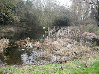
Behind the notice board and the fence is a community - made pond and pond-dipping platform. see picture below.Before the Triangle Community Garden and the pond, the footpath used to continue along the bank of the river at this point to the right of this notice board. However, the diversion through the garden is interesting and pretty, so it is well worth the few extra paces.

Pond and dipping platform
I will not be commenting in any depth about the Triangle Community Garden but would like to encourage interested people to have a look at their own website www.trianglegarden.org/ where there is a great deal of information about their activities
Diverging paths in the garden
Depending upon my whim or whether I have picked up litter on my route,(Which goes in the litter bin in the rec. behind the hedge) I will take either of these paths as they both can come out at the same place.
Walkers following Route 3 will be making their way to the right of the picture.
Walkers following Route 3 will be making their way to the right of the picture.

Route to rail station through Ransome's rec.


To the right can be seen the Kingdom Hall of the Jahova witnesses. I give them credit for planting the riverbank and grounds with bird-friendly vegetation. The 'fruits' of which were eagerly devoured last year by a flock of waxwings. These people also take on the job of keeping their plot free from the ever accumulating rubbish (credit where credit is due!)


 Grove Road entrance to Ransome's Recreation Ground
 Path and cycle track to Florence Street.


Culvert at Starlings Bridge

Many people now use this route through the garden to make their way to and from the railway station. In which case they will take the left path and follow it to the other end of the rec. and take a left along Nightingale Road. I have indeed heard Nightingales at that end of the rec., not too far away from the Nightingale pub. I wonder if that's how the name was chosen!

Route (3) through garden following the river towards Florence street

Mosaic Centrepiece of Triangle Community Garden

Arched hedge at South East entrance to garden
I include a picture of the hedge and grass for purely personal reasons, as my contribution to the community Garden is to cut these as and when needed.

Route (3) to exit garden
This is the route I take on a daily basis when walking the dog as it follows the line of the river Hiz.To the right can be seen the Kingdom Hall of the Jahova witnesses. I give them credit for planting the riverbank and grounds with bird-friendly vegetation. The 'fruits' of which were eagerly devoured last year by a flock of waxwings. These people also take on the job of keeping their plot free from the ever accumulating rubbish (credit where credit is due!)

Path towards entrance to Ransome's Rec and Florence Street.

Entrance to 'river walk' courtesy of The Hitchin Rivers Society
Many years ago The Hitchin Rivers Society also had the idea of a 'river walk' along the River Hiz and they erected the two posts as seen in this picture with 'river' and 'walk' carved on the other side of them to mark the start of the walk through Ransome's rec.
Beyond these posts is the entrance to the Rec over to Grove Road. Route 3 walkers could take this route to the Catholic church at the end of Grove Road. However, slightly to the left of the top of the picture the footpath leads to Florence Street and I would encourage people to take this route because it is not so busy and it follows the river (on the right) more closely.


Behind the privet hedge on the right is a hidden garden with pond, bird friendly vegetation and a huge 'bat-house'.
The river runs just behind this and along past the garages in Florence Street.
It is possible, but not easy, to follow the river bed but there are many bridges to cross as the garages belong to the houses in Grove Road. Best to follow Florence Street to to the junction with Nightingale Road.

Junction of Florence Street with Nightingale Road
Turn right at this junction towards Hitchin. You will be turning left into Bancroft Recreation Ground which is just beyond the white building behind the blue car to the right of the picture. However, just before you reach that point I would urge you to have a look at the river where it goes under the road at Starlings Bridge.

Culvert at Starlings Bridge
It is possible to walk the riverbed from here but I would suggest that a more pleasant route would be through Bancroft Recreation ground where there is much more to see, including Hitchin Town 's bandstand, where the band still play occasionally.

Entrance to Bancroft Recreation Ground
Keeping to the left of the recreation area you will be following the river and see it again as it emerges near the tennis courts

Bancroft tennis courts
Follow the path to the left of these courts and the river once again comes into view on your left
Junction of path at Whinbush Road entrance to Bancroft Rec.
If you take the path to your left it will bring you out on Whinbush Road by Unity House which is the home of North Herts Minority Ethnic Forum. Hitchin is alive with such groups. However, we are taking the path to the right and following the river past Sainsbury's.

The river Hiz at the back of Sainsbury's
The river looks quite wide and deep here but this has been artificially achieved by damming. We will be following the path on the left hand side of the river and this is accessed at the back of the flats to your left.
Rivers meet in Bancroft rec at back of Sainsbury's
I did not know exactly where the water came from through the culvert on the left of this river junction. I thought it might simply be a drainage point for the road at Bancroft, which would take run off from much of the rest of the town streets.However, I received this informative email 18-01-12 about the spring on Butts Close. This is a wet area that I was not sure about. I could not figure out whether it was indeed a spring and/or where the water might go to. Now we have an answer to both these questions and I will add it to the list of springs and the information to the ROUTE 3 (this walk). At this point I'm not sure how we can work in a detour onto Butts close - but Ill figure somethings out in the near future.
Thank you Keith for your contribution.
Keith Fitzpatrick-Matthews has left a new comment on your post "Purwell 'ring of springs' walking ROUTE 3 in more ...":
The stream that joins the Hiz from the culvert at the back (south-east side) of Bancroft Gardens is the Capswell Brook. This brook is now culverted for all of its length. It rises on Butts Close, where the marsh grass in the area between Archer's Gym and Hampden House on the west side of Elmside Walk marks the spring. From there, it formerly flowed north-eastwards before turning more to the east beneath the Boys' School playing fields and crossing Bancroft roughly in the position of the gap between the southern (earlier) group of buildings forming Skinner's Almshouses and the northern (later) block. The presence of the stream is the reason for the raising of the pavement on the west side of Bancroft in this area: in the nineteenth century, it was much higher and there was a tendency for the road to flood occasionally. I imagine that the current culvert is more efficient than the older, as I'm not aware of any floods in this area in recent years. The stretch east of the almshouses was still partly open in the early twentieth century, running through the nursery that stood behind Skinner's almshouses. I suspect that this part was culverted to create the bowling green when the gardens were developed in the 1930s.
Keith Fitzpatrick-Matthews
Posted by Keith Fitzpatrick-Matthews to Purwell Valley at 18 January 2012 09:01

Footbridge at the back of Sainsbury's

End of the flats as River Hiz culverts under Hermitage Road.
There is no chance of following the riverbed under the road as it is too small. You need to follow the path to your left into the end of Whinbush Road and then make you way right, down the slope in Hermitage Road until you come to the the alleyway on the left, by the side of what is now (2011) the 'Hitchin Cafe'. This alley follows the line of the river to the car park at Portmill Lane.

The alley by the Hitchin Cafe leading to Portmill Lane

River Hiz in the alley between Hermitage Road and Portmill Lane

River at Portmill Lane Car park
Just follow the river through this stretch.
You have the option of going to the left and up and down some steps, or to the right and through the churchyard. Both are pretty routes and have differences in charm. To the right gives you the opportunity of popping into a selection of bakers for some yummy snacks, or having a look in on the little shop that houses the town centre initiative - they have a great deal of information about what goes on in Hitchin. However, they also have a website so you could give this a miss and browse in your own time, in the comfort of your own home.

View of the Hitchin fountain and market

Photographer of Hitchin beauty spots.
Obviously I'm not the only one taking pictures today but I think he is much more professional than me - so I move on quickly. Personally I love to see people feeding the birds even though it is discouraged by the powers that be. We don't give over a lot of our urban spaces to wildlife so it is heartening to see that many people take no notice of pleas or dictates not to feed the birds.
The River Hiz at the Southern end of the market square.
A plug for Hitchin market here. If you walk on Tuesdays, Fridays or Saturdays you will have the opportunity of spending some money or just browsing through the famous market.
From this point 'I' would follow the river on its left hand side or even walk along the riverbed. However, the footpath is blocked by fences at the far end, so those of you who are not so inclined could either go round by the Biggin and Seebohm Gardens (below) or take a shortcut through the back of The Sun public house (on the right) and into Sun Street. Either way it'll bring you into Bridge Street by the Priory.

Seebohm Gardens next to The Biggin in Biggin Lane
You need to go around the outside to the left of the gardens and follow the road until the junction with Bridge Street where you will turn right to link up with the river again at The Priory in Tilehouse Street.
Jill Grey Place
I don't recommend you to try to get through by this route but it does give a slightly different view of the river( see pictures below)

River Hiz from Jill Grey Place to Bridge Street
(indicating obstacles to footpath access)

View of River Hiz to Bridge Street from Gill Grey Place
Personally I feel that it is a bit 'selfish' to block off footpath access to some of these pretty spots along the river. However, modern developers seem to have lost the concept of 'community spirit' in favour of more insulated, isolated and even 'gated' habitation for the increasingly self-centred human population..

River Hiz from Bridge Street into The Priory
It is possible to river walk from here but it really isn't worth the effort and if you do you'll miss the pond at the entrance to The Priory (below)
The pond at the right of the entrance to The Priory

Now, here's the tricky bit. 'I' am going to take a route through The Priory, following the river.
This is not an easy route and 'you' would possibly need waders and permission. However, the views are stunning and probably the best stretch of the River Hiz that exists. I would suggest that the best option for those less confident would be to make your way up Tilehouse Street a short way and turn left into the Old Charlton Road. follow this to the end where the footpath leads you out onto the Hitchin bypass. The river crosses here and so must you. Then just follow the river which will be on your left until you reach the Charlton Road ,where you turn left past Dog Kennel Farm. (there are pictures to accompany the detour later)
( I'll meet you there in a few minutes! as I am going through The Priory Grounds)

The River Hiz in The Priory Grounds.
I know of this stretch of river from fifty plus years back, when I used to help young people to learn to canoe here. Also, the owners at that time used to open it up once a year for 'The Priory Festival'. I believe that the grounds are now the venue for the Hitchin 'Rythms of The World' festival, so there is still the opportunity for the general public to enjoy this scenery. Meanwhile I'll show you what I see on my route by simply being cheeky and walking straight through!

River Hiz and bypass bridge in the grounds of The Priory
The river can be quite deep at this point so if you haven't got the right equipment to go under this bridge, the path can be found by following the fence left until it ends. Then turn around on the other side of the fence and make your way between the two wire fences until you rejoin the footpath. At that point it is time to cross the bypass to Charlton Road.

View from the Hitchin bypass towards Charlton
I will be making my way along the left hand riverbank from this point. Whereas, I am presuming that you will be walking along the Charlton Road. (photographs following in this blog)

River Hiz between the bypass and Charlton Road

Tree by the River Hiz between Bypass and Charlton Road.

Fallen tree across the Hiz near Charlton Road
It is possible to cross the river by means of this tree. However, this is not necessary as there is a style to access the footpath to the left of the river bank. I cross at the tree purely so that I can take a picture of the pond below.


Culvert and pond near Charlton Road footpath
There is a footpath behind the fence at the end of the pond which runs from the Charton Road to the Preston Road (see below)
Footpath from Charlton to Preston Road

Dog Kennel Farm entrance from footpath
This is where I meet you if you went round the Charlton Road route - which I will now retrace for you below.
This is where I meet you if you went round the Charlton Road route - which I will now retrace for you below.

Old charlton Road junction with Tilehouse Street
From The Priory you will have made your way up Tilehouse Street and into the Old Charlton Road.
At the end where you can just about see a lamp post on the left there is a path that leads to the bypass.
At the end where you can just about see a lamp post on the left there is a path that leads to the bypass.

Footpath to bypass at Old Charlton Road
The footpath is to the left of the car park and the right of the brick wall. If you take this route then you will need to cross the busy road. If you want to avoid this then take the footpath to the right and it will take you through an underpass and through the estate back to the Charlton Road. However, you will miss some of the river and snowdrops along the way.

View of bypass from footpath with Charlton Road opposite.

Snowdrops along riverbank
It should be pointed out that the river on this side comes from Dog Kennel Farm spring and is different to that which went on to The Priory on the route I took earlier -which comes from Wellhead and is parallel but across one field.
However, the whole of this area is 'seeping' with water and so qualifies as being one large 'spring'.

Charlton Road junction
( Where the water runs both over and under the road from Dog Kennel Farm spring -TL 176283)
If you carried on along the road towards Luton you would be able to 'percieve' the seepage of the spring in the trees behind the cottage at Dog Kennel Farm.
I say 'percieve' because it is only when I was actually walking on the ground that my footprints indicated seepage. the vegetation covers over the water table so the water is hard to see.

View of spring water from junction
As the water makes its way from dog Kennel Farm to the Charlton Road it becomes visible from the side of the road. When it rains heavily the water comes over the road at this point.
Route 3 now takes you to meet me at the entrance to Dog Kennel Farm where we carry on towards Charlton to The Windmill public house where the river runs at the rear.

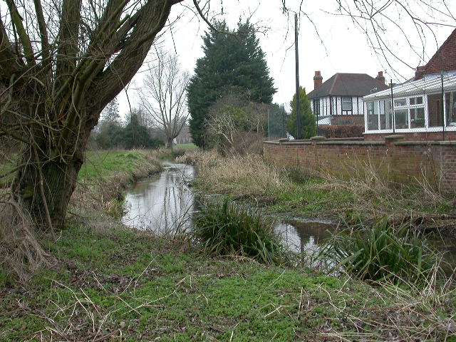
The River Hiz at the back of The Windmill pub
From here we carry on along the road to Wellhead (below)

The old ford at Wellhead Charlton
Maidencroft Lane now runs across next to where the old ford used to be. Unfortunately there is little or no water from wellhead anymore. My supposition is that the water companies have drilled deep bore holes all around this area and have sucked the groundwater dry. From the perpective of the river flow this is disastrous but unless people complain loudly enough (as they did about the drying up of Ashwell springs) then dry river beds is what results.

The spring at Wellhead from the farm

The old ford at junction of Charlton Road and Maidencroft Lane.
Our route now takes us along Maidencroft Lane to St. Ippolytes
Footpaths crossing Maidencroft Lane going from Preston to Charlton
We continue along Maidencroft Lane past Dead Womans Lane and Tatmore Hills Lane on the right and Maidencroft Manor on the left.

We continue along Maidencroft Lane past Dead Womans Lane and Tatmore Hills Lane on the right and Maidencroft Manor on the left.

Paul Bromfield's aquatic centre
There is a pond in here but I suspect that Paul made it to complement his aqauatic pursuits and it therefore has nothing to do with a 'spring' in the ring . Neither is it part of the aquifer system that feeds into the Purwell Valley.
There is a pond in here but I suspect that Paul made it to complement his aqauatic pursuits and it therefore has nothing to do with a 'spring' in the ring . Neither is it part of the aquifer system that feeds into the Purwell Valley.

The Bull at Gosmore
There is the option here to continue across this junction and on to St Ippolytes crossroads. However, turning right takes us on a much prettier route.

Crocusses near The Bull at Gosmore

Junction to Poynders Meadow and St. Pauls Warden
Take the left turn here towards Poynders Meadow, past Thistley Farm; Cottage;View & House, on to the next junction.
Take the left turn here towards Poynders Meadow, past Thistley Farm; Cottage;View & House, on to the next junction.

Junction past the 'Thistleys' -
Turn left and follow the lane to the Codicote Road by St. Ibbs Lodge
Turn left and follow the lane to the Codicote Road by St. Ibbs Lodge

Snowdrops at the back of St. Ibbs Lodge

View of footpath across the Codicote Road from St. Ibbs Lodge
This will be the path you take to the next spring.
This will be the path you take to the next spring.

St Ibbs lodge from the footpath to St. Ibbs Spring

Footpath to St. Ibbs Spring TL195260

View from bridge at St. Ibbs towards Little Almshoe
A little explanation is in order at this point. The pond that you see has only been excavated to this amount during the past month or so and the dredgings are scattered up the hill. It does improve the scenery and shows a definite level of the water table. However, having walked the length of the spring /river bed I am convinced that the whole area is seeping spring water from this point right through to Little Almshoe. This would put the furthest point of the spring somewhere near the farm some half a mile upstream of this view.
The ordnance survey map actually puts the spring somewhere near the road outside Henry Isaacs foundry in St. Ippolytes, but this is clearly not so on the ground.

Footpath to St. Ippolytes churchyard
Turn left at the road and make your way past the church then veer right.

St. |Ippolytes Church

Junction at the church in St. Ippolytes
Veer right at this junction. The river runs from Henry Isaac's, parallel to the road in the bottom of the valley to your left. However, it is really not worth the effort to follow the river bed as there is little more to see than that which can be viewed from the road and it all runs through private land.
Follow this single track road and turn left when you reach the Stevenage Road.
I would advise trying to cross the road at this point to utilise the footpath on the other side. There is no footpath on the left of the Stevenage Road and the traffic regularly break the speed limits along this stretch.


I would advise trying to cross the road at this point to utilise the footpath on the other side. There is no footpath on the left of the Stevenage Road and the traffic regularly break the speed limits along this stretch.

Looking back along River at junction with Stevenage Road Hitchin
(with The Willows on the right.)
(with The Willows on the right.)

Footpath from Stevenage Road at back of Oakfield Avenue

Footpath and river outlet at back of Oakfield Avenue

Footpath at back of Oakfield Avenue

Footpath at back of Oakfield Avenue

Rivers meet near recreation ground.
This is the point where we briefly meet with route 2. Make your way to the left of the play area and on to the Wymondly Road where we turn right to go under the rail bridge and on to the roundabout.
(An email from A blog follower about another spring in this area)

Hi Stuart
Getting back to you at last re the spring I was mentioning.
Here are three photos. I will send them separately as well a little larger.
The centre one shows the pipe coming from the pond which was filled in some years ago. There was always a pipe taking the spring water from the pond to the Ashbrook here.
The pond was in line from the pipe in the position where the ploughed field meets the grass - a distance of around 15 metres.
The first picture is a close up of the point of entry to the Ashbrook and the third photo shows the area in question at the bend in the river.
The grid ref is TL 204 283
The path follows the Ashbrook from the bridge over the St Ippollytts brook in the recreation ground in Ninesprings Way.
The Ashbrook joins the St Ippollytts brook 20 metres to the right of the bridge. The pond was at the bend in the Ashbrook.
I remember as a child watching the springs bubble up into the pond.
The farmer says that the area is often wet there and the spring was filled in before he took over, perhaps to release a little more cultivatable land.
Stuart, hope this is of interest.
I have known Derek Turner for years. He speaks admiringly of The Hutton Highway along the Hiz.
Regards
David Day
(An email from A blog follower about another spring in this area)
Hi Stuart
Getting back to you at last re the spring I was mentioning.
Here are three photos. I will send them separately as well a little larger.
The centre one shows the pipe coming from the pond which was filled in some years ago. There was always a pipe taking the spring water from the pond to the Ashbrook here.
The pond was in line from the pipe in the position where the ploughed field meets the grass - a distance of around 15 metres.
The first picture is a close up of the point of entry to the Ashbrook and the third photo shows the area in question at the bend in the river.
The grid ref is TL 204 283
The path follows the Ashbrook from the bridge over the St Ippollytts brook in the recreation ground in Ninesprings Way.
The Ashbrook joins the St Ippollytts brook 20 metres to the right of the bridge. The pond was at the bend in the Ashbrook.
I remember as a child watching the springs bubble up into the pond.
The farmer says that the area is often wet there and the spring was filled in before he took over, perhaps to release a little more cultivatable land.
Stuart, hope this is of interest.
I have known Derek Turner for years. He speaks admiringly of The Hutton Highway along the Hiz.
Regards
David Day

Roundabout at Wymondley Road and St. Michael's Mount.
If you remember, route 2 took us straight on to Coots Corner. However Route 3 takes us along the footpath marked by the sign in the middle, behind the two bollards. The footpath goes left, following the river at the back of Tennyson Avenue.

Footpath at back of Tennyson Avenue

Footpath at back of Tennyson Avenue

View of Coots Corner Lakes from Footpath at back of Tennyson Avenue

Rivers meet - view from Footpath at back of Tennyson Avenue
From here can be seen some good views of Purwell Water Meadows. It is likely that this, and Coots Corner are all areas of natural springs. However, I have not documented them as such because of the river systems running into this area. It 'might' simply be a flat area where the water is collecting rather than springing from the ground.

Footpath at back of Chaucer Way.
Here the river parts company with the footpath and makes its way for a few yards to the Purwell Mill junction. Just follow the path on the left.

Junction of path to Purwell Mill behind Chaucer Way
Route 2 is to your right at this junction. However, for route 3 we need to follow a small stream along the back of Chaucer Way - which is straight on in the picture.

Footpath and Purwell Mill from Chaucer Way footpath

Streams meet along Chaucer Way footpath

Footpath to Hitchin College
There is a footpath to the grounds of Hitchin College which runs straight ahead in this picture and left behind the garages in the next pictures. However, we are taking the river- route, which is a path to the right of these houses alongside the wooden fence. It is not readily apparent from this picture or from the footpath but it is there to be walked.

Footpath to Hitchin College

Culvert under Chaucer Way
You may notice that this stream is still not the same as the main Purwell River which runs parallel with it some yards awayacross Purwell Meadows. For Route 3, we will stay with this one through the college grounds.

Footpath to Hitchin College (River on right of picture)
If you make your way to the bend in the path, there is a hole inthe fence which leads onto the college grounds. If you keep to the right you will be following the river all the way to the Cambridge Road.
North Herts College grounds (formerly Hitchin College) from Chaucer Way end

Footpath through Hitchin College to Cambridge Road.

Footpath at the back of the Millstream Pub.
There is a pedestrian crossing just to the right where the car is just seen in the picture. When people are crossing and stopping the cars, it is safe to cross here and pick up the footpath behing the Millstream pub.
It is here that we rejoin route 2. to make our way back to base.

Footpath through car park at the back of the Millstream pub.

'Scrape' in Walsworth Common.
This 'scrape' is designed for wildlife and is maintained by the Countryside Management Service with help from the Friends of Purwell Valley.
This 'scrape' is designed for wildlife and is maintained by the Countryside Management Service with help from the Friends of Purwell Valley.
River Purwell at back of Green Lane, in Walsworth Common.
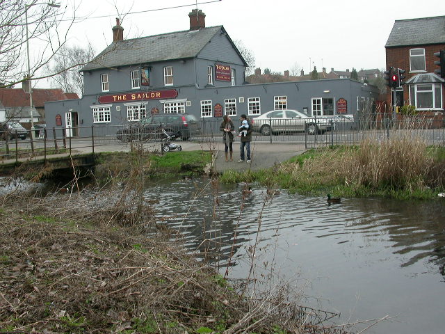
Feeding the ducks near The Sailor (formerlyThe Sailor Boy)

Still feeding the ducks

River Purwell in Walsworth Common
with Riverrain Bowls club and car park on right)
We are still walking on the left of the river towards the footbridge at the end of Walsworth Common.
Walsworth Common

Footbridge over River Purwell at north end of Walsworth Common
When I get the footpath to a walkable state under the rail bridge, it should be possible to carry straight on here, under the rail bridge and through the spinney to the centre of the 'ring of springs'.
However, for now, walkers without waders will need to go over the river bridge, to the Walsworth Road, where you turn left and then left again at the traffic lights. It is but a short way down the slope in Grove Road to end up at the centre of the 'ring of springs', which is the end of route 3
I hope you have enjoyed this walk.
The bridge carrying the Hitchin Bypass from The Priory grounds
River Hiz in Jill Grey Place (path blocked)
Bridge over the river behind Sainbury's
The stream that joins the Hiz from the culvert at the back (south-east side) of Bancroft Gardens is the Capswell Brook. This brook is now culverted for all of its length. It rises on Butts Close, where the marsh grass in the area between Archer's Gym and Hampden House on the west side of Elmside Walk marks the spring. From there, it formerly flowed north-eastwards before turning more to the east beneath the Boys' School playing fields and crossing Bancroft roughly in the position of the gap between the southern (earlier) group of buildings forming Skinner's Almshouses and the northern (later) block. The presence of the stream is the reason for the raising of the pavement on the west side of Bancroft in this area: in the nineteenth century, it was much higher and there was a tendency for the road to flood occasionally. I imagine that the current culvert is more efficient than the older, as I'm not aware of any floods in this area in recent years. The stretch east of the almshouses was still partly open in the early twentieth century, running through the nursery that stood behind Skinner's almshouses. I suspect that this part was culverted to create the bowling green when the gardens were developed in the 1930s.
ReplyDeleteKeith Fitzpatrick-Matthews
Thank you very much Keith for this information which I will now add to Route 3 in the most appropriate place. When I get the opportunity I will photograph the wet area in Buts Close and add it to the route- perhaps suggesting a detour for the walker to see it for themselves.
DeleteStuart